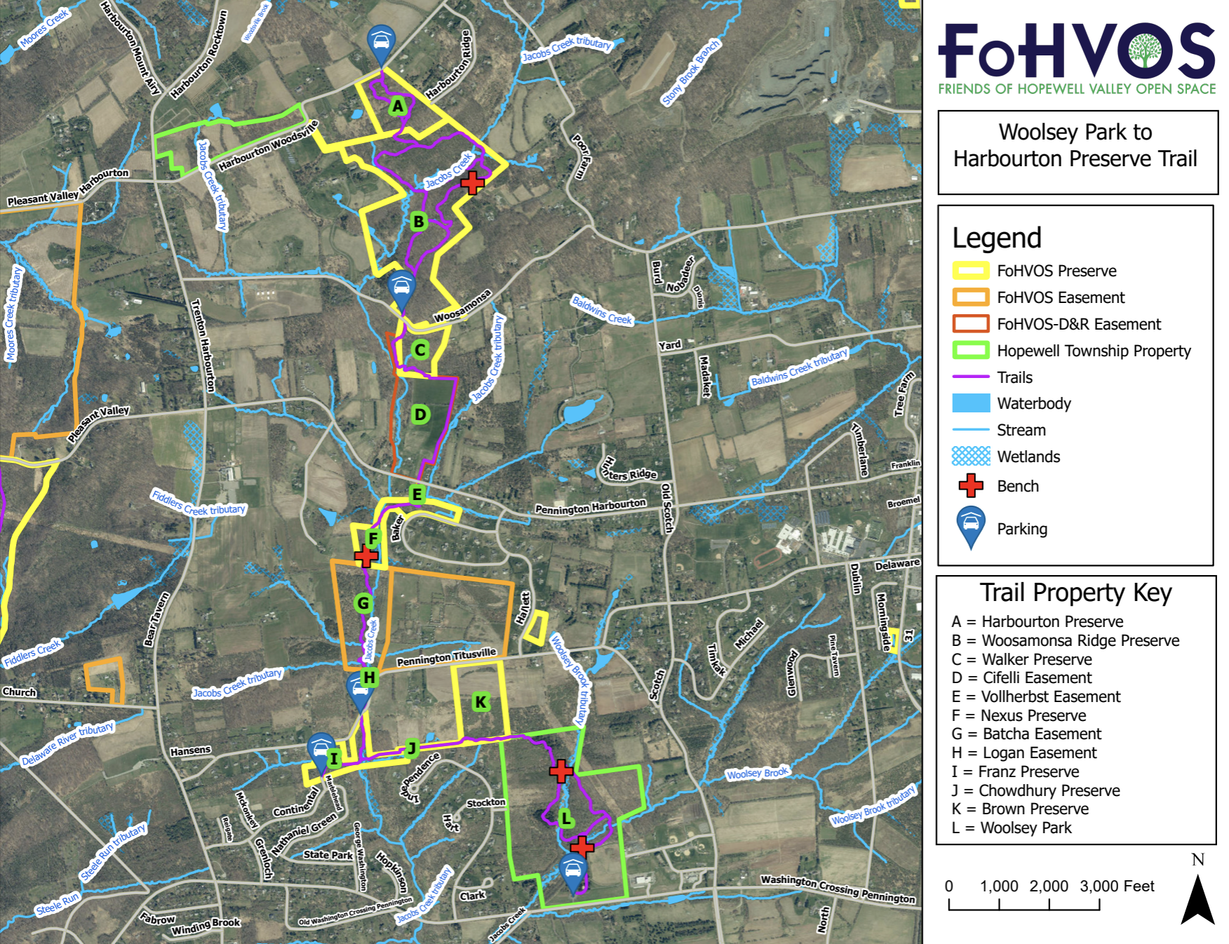
This 5.5 mile linear trail is Hopewell Valley’s longest trail. It was created by linking trails in over 350 acres of various preserves and easements, ultimately connecting to Hopewell Township’s Woolsey Park. In the northern end, the trail starts at Harbourton Preserve, running along Jacob’s Creek, to finally conclude south at Woolsey Park.
This 5.5 mile linear trail is Hopewell Valley’s longest trail. It was created by linking trails in various preserves, easements, and Woolsey Park as shown on the trail map. The trail’s most easily accessible starting point is at the southern end in Woolsey Park. Hikers can access the connecting trail to Jacobs Creek by taking the Osage Ridge Trail (red blazes) to its furthest point. There is a sign and a post at the junction of the two trails and a wide opening in the line of Osage orange trees to pass through.
The connecting trail to Jacobs Creek ends with a crossing of the creek on stepping stones which in high water may not be passable. The Jacobs Creek Trail brings hikers to Pennington-Titusville Road which must be crossed to continue on the trail going north. During hunting season, the next section of the trail on a couple privately granted easements is only accessible on Sundays and Mondays.
A second crossing of Jacobs Creek occurs about a mile from Pennington-Titusville Road. Approximately one third mile later, after crossing a smaller creek, the trail comes to Pennington-Harbourton Road. There is a gap in the trail here as hikers must cross the road and walk west along the road for about 50 feet. At that point, the trail heads to the right along the edge of farm fields. At the highest point of the fields, the trail enters a wooded area. After about a half mile, it reaches Woosamonsa Road.
On the opposite side of the road are steps up an embankment. From there, the trail veers left a short distance to reach the Woosamonsa Ridge Preserve parking area and kiosk. Hikers should take the white Ridge Trail to its furthest point and look for a trail leading up a steep slope on the right. There is a sign for the Harbourton Preserve Trail at the trail junction. Near the top of the slope, the trail divides to form a large loop which will bring hikers back to the same point. At the furthest point of the loop, there is a short trail to a parking area on Harbourton-Woodsville Road. (The address to find online is 144 Harbourton-Woodsville Road.)

Click here to download a PDF version of Woolsey Park to Harbourton Trail.
Maps of individual trail properties: Harbourton Preserve (A); Woosamonsa Ridge Preserve (B); Walker Preserve (C); Cifelli Easement (D); Vollherbset Easement (E); Nexus Preserve (F); Batcha Easement (G); Logan Easement (H); Franz Preserve (I); Chowdhury Preserve (J); Brown Preserve (K); Woolsey Park (L)
Click here to use our interactive GPS Map.
There are multiple parking spots along the trail. At the northern end, parking is available at Harbourton Preserve along Harbourton-Woodsville Road. Parking is also available at entrance to Woosamonsa Ridge on Woosamonsa Road and at Franz Preserve (407 Pennington-Titusville Road). At the southern end of the trail parking is available at Woolsey Park.
