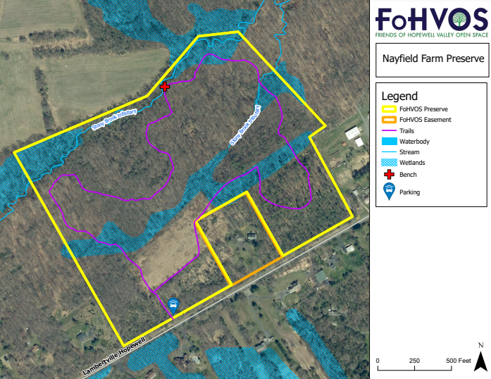
Nayfield Preserve was historically used for agriculture, including cropland and white pine plantation. However, the northeastern and northwestern corners were forested in 1930 and harbor an array of tree species, woodland wildflowers and shrubs such as American beech, toothwort, bloodroot, mayapple, witch hazel and maple leaf viburnum. A trail loops through the preserve’s meadow and forest habitats. It is co-owned with the New Jersey Department of Environmental Protection.
This is a very pleasant walk through many different habitats including farm fields, mature oak-hickory forest, red maple forest, some red cedar woods, and a pine grove. Parts of the trail may be swampy or muddy in the spring. A portion of the trail runs along a tributary of the Stony Brook which has a bed of large flat rocks. Stream flow is high in the spring and you can watch the water cascading over the rocks at several vistas. Spring woodland flowers include jack-in-the-pulpit, mayapple, dogwood and large areas of trout lily. In summer the forest canopy closes providing abundant cool shade. In fall the preserve hosts a multitude of colors from wildflowers in the wet meadow and trees in the hardwood forest. In winter the meadow provides a valuable source of food for winter resident birds and the snow stands in stark contrast to the dark trees and grapevines.
The land where Nayfield Preserve stands today was used as a dairy farm until the early 1960’s. Thickets and trees started growing in various fields after farming activity was abandoned. The exception was a five acre corn field that was used through the 1970s. Over the years, the field has reverted to a wet meadow and the forest has continued to grow and mature.
Click here to view a pdf version.
Click here to read the stewardship plan for detailed ecological information.
The Nayfield Preserve has a grassy parking area with room for 3-4 cars. The parking lot is accessible from the road – look for the FoHVOS Nature Preserve sign. For directions, click here. Use the address 312 Lambertville-Hopewell Road, Lambertville, NJ for a GPS, or the coordinates 40.375427, -74.840253.

